Galloway description 1654 "The inhabitants engage in fishing both in the surrounding sea and in…
Nithsdale Annandale Eskdale Ewesdale West March of Scotland Maps 1580 – 1665
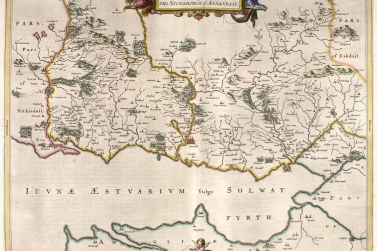
Annandale 1645 Map
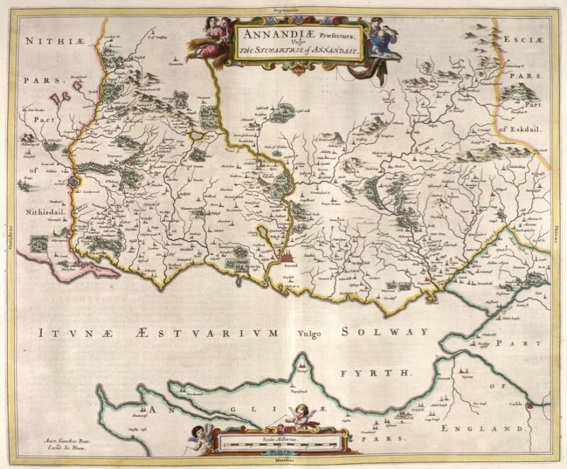
Annandale 1654 Map: Charting the Nation website
National Library of Scotland: Annandale Map:
Annandale Text The text explains the feuds of Johnsons Maxwells. Robert Bruce & Balliol is explained.
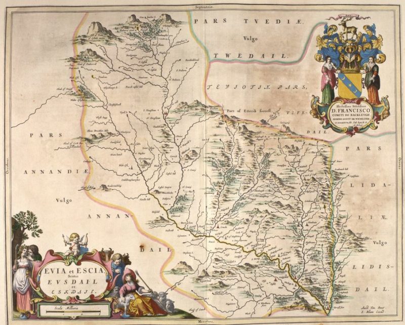
This map shows south Dumfriesshire from the River Esk in the east to the Lochar Water in the west, including the catchment of the Kirtle Water and lower Annandale south of Dalton and Castlemilk. Castles are prominent, as is the ‘Tour of Repenta[n]ce’, south of Hoddam Castle. Coverage of Upper Annandale on the northwest margins of this map appears to be incomplete and is not covered by any other map by Blaeu. The map was compiled from observation on the ground by Timothy Pont in the last two decades of the sixteenth century. It was engraved in Amsterdam, for publication in Blaeu’s Atlas Novus, first published in 1654.
Annandale starts at a steep sided bowl at head of the valley where the twisting narrow valley made a perfect hiding place for the cattle that reivers raided, hence its name “The Devil’s Beeftub”. The River Annan flows through Moffat to the wide flat area between the lochs of Lochmaben and Lockerbie where it collects the Water of Ae and the Dryfe Water and meanders until it meets the Water of Milk at Hoddom Castle and discharges into the Solway Firth at Annan.
Note that the Ordnance Survey marks the locally known “Clochmabenstane” as the “stone of lochmaben” where the English and Scottish Wardens of the West Marches met to resolve their business is near Gretna and not at the town of Lochmaben.
Annandale Eskdale and Liddesdale 1725 Map
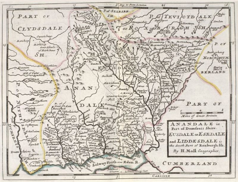
Annandale Eskdale and Liddesdale 1725 Map: National Library of Scotland website
A map of Annandale in eastern Dumfriesshire, and southern Roxburghshire (Eskdale and Liddesdale) from Moll’s 1725 atlas of Scottish shires. The two areas are separated from each other by a dotted line and from surrounding shires by dotted coloured lines. Some settlements are absent, notably Lockerbie, and Moffat which, though not yet a famous spa town, had become a burgh. Additionally, Lochmaben is placed on the Lochar Water. Based in London, Moll depended on the work of other cartographers and surveyors for his information, citing Adair, Pont and Gordon. However, he made no mention of his use of Blaeu’s atlas.
The Debateable Land is no longer shown but the “March Dyck” shows the line of compromise between the Scottish and English claims, though the border is the northern boundary of the now extinguished Debatable Land. Compare this map to the 1654 map and note the absence of tower and settlements, although the description from the “Mapping The Nation” site explains that the map maker may have relied on incomplete information.
Eskdale & Liddesdale: West March of Scotland
Eskdale Liddesdale drawing 1633: Charting the Nation website
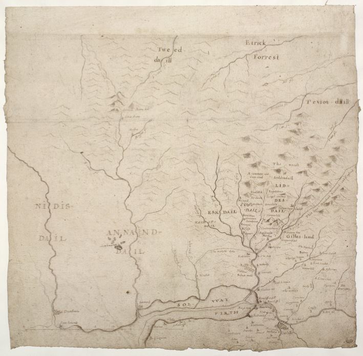
Eskdale Liddesdale sketch by Robert Gordon sketch from Timothy Pont observations. This map of Eskdale and Liddesdale in the Borders is an uncompleted draft compiled by Robert Gordon of Straloch (1580-1661), at an unknown date after 1633. It includes a part of the Solway Moss which lies to the south of the border between England and Scotland and the coastal outline of the Solway Firth. The detail includes both settlement and named hills. The main source of the compilation is likely to be the observations of the mapmaker Timothy Pont (?1580-?1614), in the last two decades of the sixteenth century.
Eskdale & Liddesdale drawing after 1633: West March of Scotland
Eskdale Liddesdale drawing 1633 : Charting the Nation website
A map of the western part of the border lands between England and Scotland, compiled by Robert Gordon of Straloch (1580-1661), at an unknown date after 1633. It includes the River Nith on the west, the upper reaches of the Tweed and Teviot in the north, the lower reaches of the Eden in the east and Cumbria west of Carlisle in the south. Settlement detail is confined to Ewesdale, Eskdale and northern Cumbria. The source of much of the Scottish coverage was probably the observations on the ground of Timothy Pont, in the last two decades of the sixteenth century, but the origins of the coverage south of the border has not yet been established.
The border between Scotland and England is shown and goes along The Marche Dyke but the later map by Moll 1725 shows the border to the north of the “March Dyck”. See file: Annandale Eskdale and Liddesdale 1725
Eskdale & Ewesdale: West March of Scotland
Eskdale Ewesdale Liddesdale map 1654: Charting the Nation website
Annandale is to the West, Liddesdale to the East with Teviotdale and Tweeddale to the North.
Liddesdale & The Debateable Land: The Middle March of Scotland
 Liddesdale with Debateable Land 1664 Map: Charting the Nation website
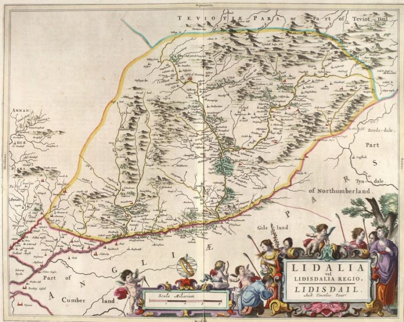
Liddesdale showing the Debateable Land Printed in 1664 possibly from notes from Pont Gordon 1580 – 1614
Nithsdale. West March of Scotland. Dumfries and Galloway
Nithsdale 1654 Map : Charting the Nation website
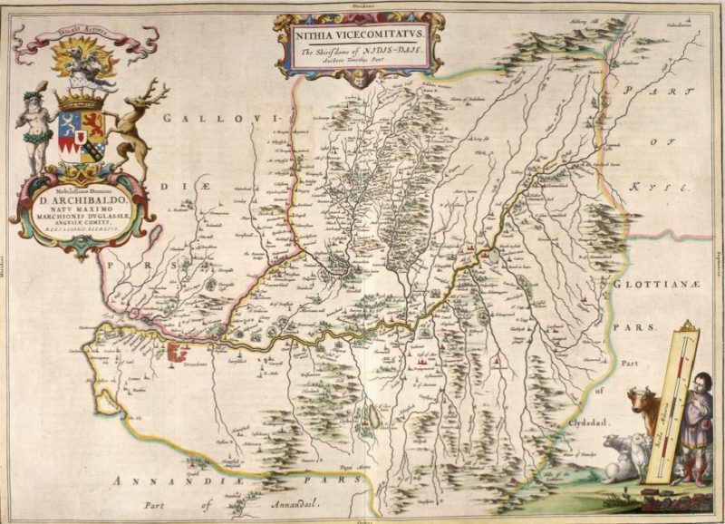
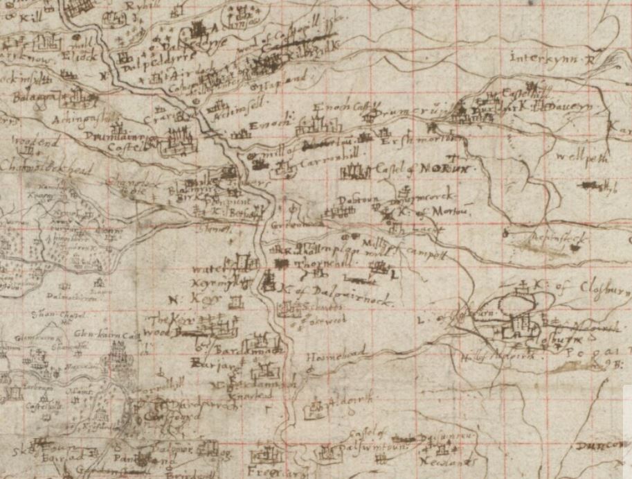
This map was first published in Blaeu’s ‘Atlas Novus’, in 1654. It was engraved in Amsterdam from a manuscript draft by Timothy Pont, which was returned to Scotland and is now in the National Library of Scotland. The area covered on this map is bounded by the watershed of the River Nith, thus showing all of Nithsdale from Dalmellington to the Solway Firth. It is oriented with west at the top. The detail of a dense distribution of rural settlement is evident, particularly along the Shinnel Water and the River Cairn, both west-bank tributaries of the Nith. Criffel was omitted by the engravers but the bridge over the Nith at Dumfries is shown. The official language in 1654 was Latin so the map has a title in Blaeu Atlas “NITHIA VICECOMITATUS. The Shirifdome of NIDIS-DAIL [2 of 3] 1654”
Nithsdale drawing by Robert Gordon from manuscript by Timothy Pont
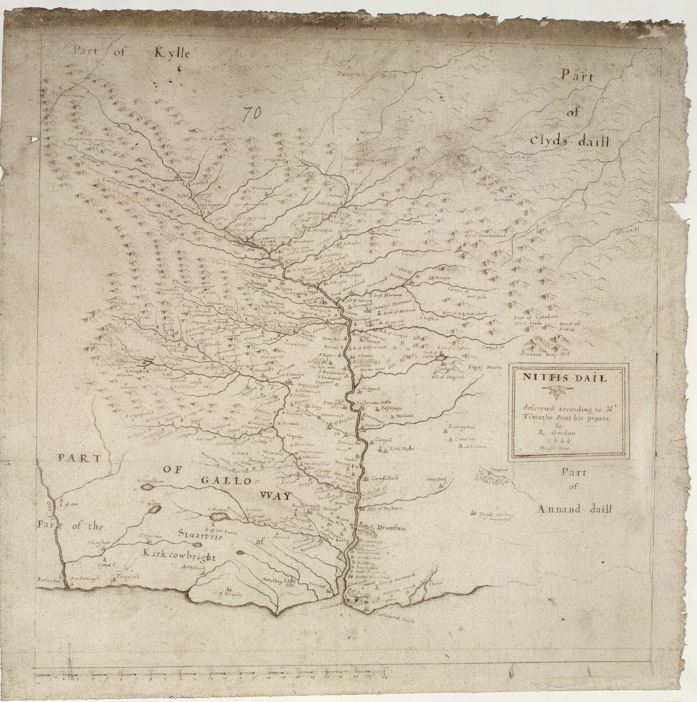
Nithsdale Pont drawing 1644 : Charting the Nation website
Nithsdale 1644 Manuscript hand drawn sketch map / plan by Timothy Pont. This map of the catchment of the River Nith, together with a small part of southeast Kirkcudbright, was compiled by Robert Gordon of Straloch (1580-1661) and is dated May 1644. Apart from southeast Kirkcudbright, the map derives from a manuscript map of Nithsdale by Timothy Pont now in the National Library of Scotland and compiled from observations on the ground in the last two decades of the sixteenth century. This is, however, a reduction of Pont’s map, both in overall size and in content, omitting some of Pont’s named features. Furthermore, it includes fewer named features than the map entitled NITHIA published by Blaeu in his ‘Atlas Novus’ of 1654, which also derives from the extant Pont map.
Nithsdale original sketch map 1600 Dumfries West March of Scotland
Nithsdale Pont original sketch map: National Library of Scotland website
Nithsdale description from Pont’s manuscript
Pont Maps National Library of Scotland website
